Home > Gloucester
Gloucester Harbor
Location and Description
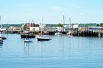 Gloucester’s
heart is its harbor. The harbor is the city’s greatest
scenic and economic asset.
Gloucester’s
heart is its harbor. The harbor is the city’s greatest
scenic and economic asset.
Discovered in 1605, mapped in 1606, and named LeBeauport (the
good port) by the famous French explorer Samuel Champlain,
Gloucester’s large harbor and its proximity to ample
fishing grounds have enabled Gloucester to be synonymous with
fishing for the last two centuries. Gloucester has thrived
on fishing, and even though the industry has declined because
of ecological and regulatory factors, Gloucester harbor is
always busy and beautiful.
 The harbor is located in the southeastern portion of Gloucester.
The mile and a half wide mouth of Gloucester’s outer
harbor is marked on the west by Norman’s Woe and on the
east by the Eastern Point Lighthouse. Two miles into the outer
harbor, a passage between Fort Point and Rocky Neck leads to
the sheltered three quarter mile long inner harbor, with the
Jodrey State Fish Pier at its center.
The harbor is located in the southeastern portion of Gloucester.
The mile and a half wide mouth of Gloucester’s outer
harbor is marked on the west by Norman’s Woe and on the
east by the Eastern Point Lighthouse. Two miles into the outer
harbor, a passage between Fort Point and Rocky Neck leads to
the sheltered three quarter mile long inner harbor, with the
Jodrey State Fish Pier at its center.
Directions to Gloucester Harbor
To drive to Gloucester harbor
- From Essex and West Gloucester, take route 133.
- From Manchester-By-The-Sea, take route 127 north. Route
133 and route 127
meet on the west side of the outer harbor at Stacy Boulevard in Gloucester.
The
Gloucester Visitors Welcoming Center is nearby the intersection of routes 127
and 133 in Stage Fort Park.
- From route 128, at exit 11, the rotary at Grant Circle,
take Washington St
directly downtown to Rogers St., which is by the entrance to the inner harbor.
- From Rockport, take route 127 to the end of the inner harbor
at the intersection
of Main St. and East Main St.
Go to Stop 1 on the Poetry Tour:
Norman's Woe