Home > Gloucester > Eastern Point
Eastern Point (Gloucester Harbor)
Location, History, and Legends
Location and Description
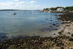
Eastern Point is the southern half of the peninsula between the Atlantic Ocean and the eastern side of Gloucester Harbor. Without the peninsula, there would be no harbor. Eastern Point is about a mile and a half long and stretches from just north of Niles Beach to the Eastern Point Lighthouse and Dog Bar Breakwater, which are located at its southern tip. To reach the lighthouse, travel down the eastern side of the harbor on East Main St., which becomes Eastern Point Blvd. at Niles Beach.
History and Legends
The history of Eastern Point is both the history of shipwrecks and efforts to reduce their number and a history of the privileged class which settled and developed Eastern Point. Both facets of Eastern Point’s history are covered in detail by Joseph E. Garland’s excellent book, Eastern Point ( Beverly, MA: Commonwealth Editions 1999).
In 1728, during the heyday of the Commons Settlement in the Dogtown section of Gloucester, fifteen families lived on Eastern Point. After the Revolution, Daniel Rogers, a forebear of Joseph Garland, owned a large farm that took up most of Eastern Point. In 1844, Thomas Niles acquired this 450 acre farm, and in 1859, the “irascible” Niles, as Garland characterized him, won a state Supreme Court ruling barring the public from access to most of Eastern Point. This helped create a mystique of exclusivity for Eastern Point, which even modern visitors can feel as they drive through two gates to reach the lighthouse.
 During the Civil War, in 1863, a small fort named Fort Independence, was built by the Union Army on the Niles farm on Fort Hill Ave. Equipped with seven cannons, it was designed to protect Gloucester harbor from a Confederate attack, something which never happened. In 1867, the fort was abandoned, and in 1869, Niles petitioned the government for financial compensation, a small portion of which his survivors received in 1890. Also in 1869, Niles reasserted his right to bar public access to his property.
Development of Eastern Point as a vacation spot for the wealthy began in 1887, with the sale of the Niles farm to the Eastern Point Associates. The next year, construction began on what would eventually be eleven "cottages”, many of which can easily be seen today. The magnificence of the interior of these dwellings can also be experienced today by visiting “Beauport,” a 40 room house on Eastern Point designed and built by Henry Sleeper from 1907 to 1934. “ Beauport” is open to the public and operated by Historic New England, formerly The Society for the Preservation of New England Antiquities. In 1892, the Eastern Point Associates went bankrupt, primarily because they could not provide an infrastructure on Eastern Point for the homes they were building. Perhaps the peak of Eastern Point’s caché as a vacation spot came in 1904 with the construction near Niles Beach of the Colonial Arms, a six story 300 room luxury hotel, which unfortunately burned down in 1908.
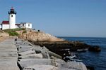
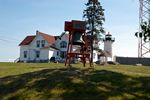 The navigational hazards surrounding Eastern Point were addressed by the installation of a lighthouse on the tip of Eastern Point in 1831. On New Year’s Day 1832, the light was lit for the first time by the light’s first keeper, Samuel Wonson. The carelessly designed and leaky lighthouse was rebuilt and modernized in 1848 by Winslow Lewis, the leading American lighthouse builder of the time and a pioneer in the development of navigational aids. A red lamp, the Ruby Light, was installed atop the lighthouse, and the remodeling was done in an astounding eighteen days. In 1857, an automatic fog bell, which needed to be rewound every two hours, was added and the Ruby Light was enhanced. In 1890, the lighthouse was rebuilt as it stands today, and subsequent improvements have included the installation of a radio beacon in 1937, the replacement of the bell with an electronic signal in 1969, and the automation of the light in 1985, after which a keeper was no longer necessary. In 1987, Eastern Point Lighthouse was added to the National Register of Historic Places.
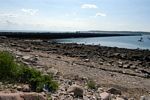 The Dog Bar Breakwater, extending one half mile into the mouth of the outer harbor from Eastern Point Light was first proposed in 1866 in order to reduce turbulence in the waters of the outer harbor during heavy weather. In 1866, Captain “Uncle Joe” Proctor, the “father of the Dog Bar Breakwater,” petitioned Congress for its creation, but it was not until 1894 that work on its construction began. Progress was slow, and although an extraordinary number of shipwrecks and groundings in 1898 sped it up somewhat, the breakwater was not completed until 1905.
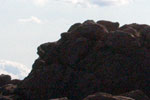 One unique feature of the shoreline at Eastern Point Light is the rock formation called Mother Ann. This silhouette of a woman’s face was named by Captain William Thompson of Salem in 1891, although his claim to have “discovered” Mother Ann is disputed. In 1892, Ada C. Bowles published The Old Man of the Mountain and Old Mother Ann, comparing Mother Ann with New Hampshire’s famous rock formation (Boston: Press of Anna Florence Grant). “Carved by God’s angels” according to Alex Tupper’s article in a 1923 issue of North Shore Breeze, Mother Ann looks seaward, searching for men who have yet to return to Gloucester’s safe harbor. The whistling buoy offshore at Eastern Point is known as “Mother Ann’s Cow”, and the feminine cast of these “nurturing” features of Eastern Point along with Elizabeth Stuart Phelp’s poem, “The Stone Woman of Eastern Point” and Vincent Ferrini’s poem, “The Bone Shop of Eastern Point” give the area a decidedly feminine aura, in contrast to the masculine Norman’s Woe at the opposite end of the outer harbor.